


James Stoddart is an aspiring architect living in New York City. He attended the Georgia Institute of Technology in Atlanta, earning a B.S. in Architecture, and completed studies in Barcelona and Paris, spending his final year at the École Nationale Supérieure d'Architecture de Paris La Villette. After having worked for several years as an intern architect and project manager at Gamble + Gamble Architects in Atlanta, James is now pursuing his Masters of Architecture at the Graduate School of Architecture, Planning, and Preservation (GSAPP) at Columbia University, where he has just completed his first year.
While 2010 population estimates place Mexico City proper, with 8.873 million residents, as the 25th most populous city in the world the metropolitan area ranks as the third most populated, with over 22.07 million residents. This highly populated and ever expanding sprawl has generated one of Mexico City's least desirable characteristics, the worst traffic in the world (according to the 2011 IBM Commuter Pain Index). With nearly 10 million cars on the road, the average commuter faces, on average, 2.5 hours stuck in traffic heading both into and out of the city.
The overwhelming amount of vehicular traffic also brings with it another of Mexico City's undesirable characteristics, air pollution. In 1992, the UN ranked Mexico City at the world's most polluted city, a designation that carries serious health impact for the city's residents. At it's worst point, air pollutants were causing residents to lose their sense of smell, ozone remained at dangerous levels for 333 days of the year, and birds were reported to be falling dead out of the smoggy skies.
In the decades since the early 90s, the Mexico City government has taken great strides in improving air quality and developing new transit to alleviate some of the traffic burden. However, the city still faces the challenge of a booming population, expanding suburbs, a geographic situation that traps pollutants, and a public perception that improvements over the last 30 years have remedied the city's issues.
This project seeks to re-imagine the view of the city, coupling big data with a traditional representation of the city in order to generate a new visualization strategy that reflects the impact of human movement through the urban infrastructure. Simultaneously, this project also looks at the relationships between the way the populace moves through the city, and the environmental impact those movements produce. When examined together, we can draw conclusions about causality, identify pollutants that remain a problem and others that have seen improvement, and highlight areas of the city that are most at risk for poor air quality.
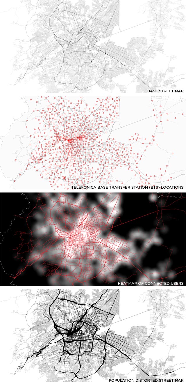
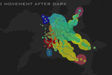
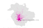
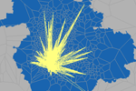
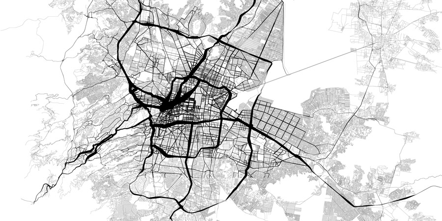
The distorted maps are produced using a combination of GIS roadway data and population density "heat maps", generated from aggregated cell phone data, provided by Telefonica, that show hourly connectivity to the providers base transfer stations (BTS). Through a conversion from polylines, to rasters, and then to points, the street data was embedded with hourly population changes. Utilizing custom scripts in Processing, the streets were then drawn dynamically, varying in thickness to represent the relative number of people in areas throughout the city. These distortions were generated to show hourly changes for each day of an average week.
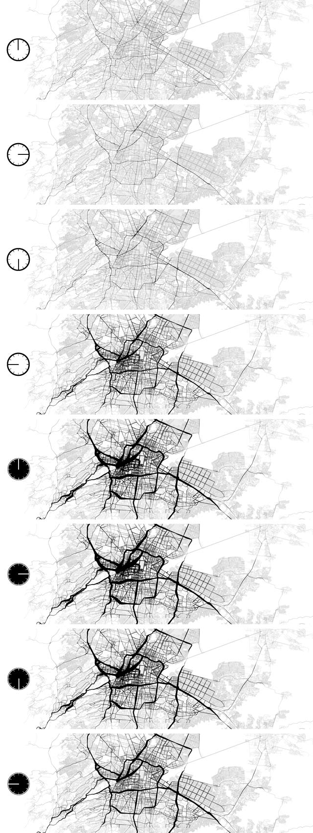
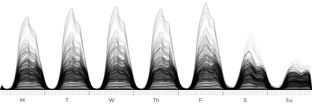
This information was also represented in a more traditional graph, paralleling the pulsation seen in the animated maps. This graph would also served as a baseline reference for pollutant tracking.
To track pollutants, data was gathered from public databases provided by the Índice Metropolitano de la Calidad del Aire (IMECA) and the Sistema de Monitoreo Atmosférico (SIMAT). Five pollutants were selected for tracking: Ozone (O3), Carbon Monoxide (CO), Sulfur Dioxide (SO2), and Particulate Matter at 10 and 2.5 microns. These five were selected due to their well understood linkage to automobile exhaust, and their deleterious health effects, especially to individuals with compromised respiratory systems, children, and the elderly.
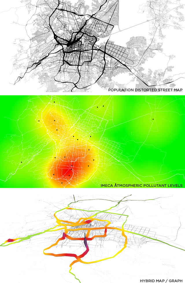
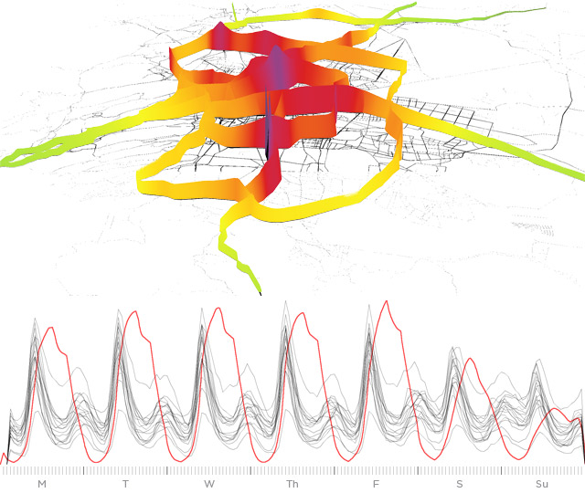
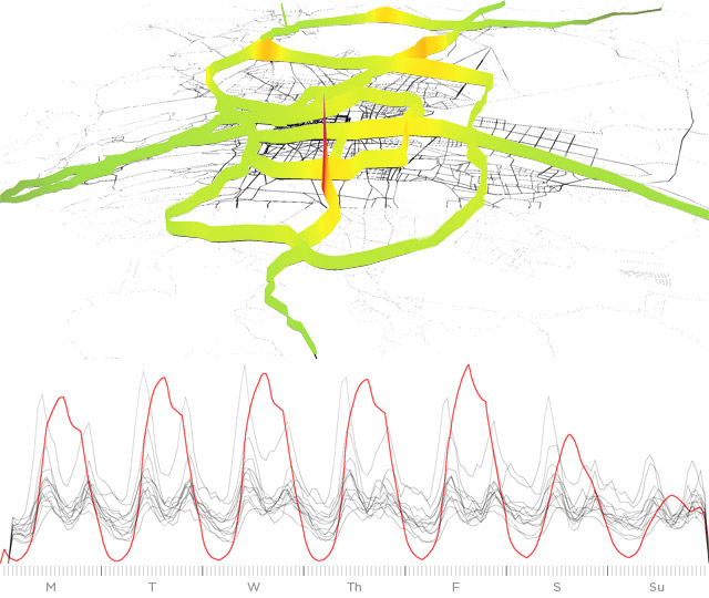
Using the raw measurement data and monitoring station locations, an algorithm in the Processing script dynamically calculated the relative exposure levels along each point of the roadway. This was then articulated in the z-axis, developing a hybridized visualization of map and graph. The raw data was processed to correspond with the movement data, so the two could be overlaid. As with the movement data, a second set of graphs were generated and overlaid with the population density graph (the red line). This second set of visualization illuminates which pollutants have a direct relationship to morning and evening commutes, which pollutants dissipate quickly and which linger, and pollutants that show improvement and those that remain a problem.
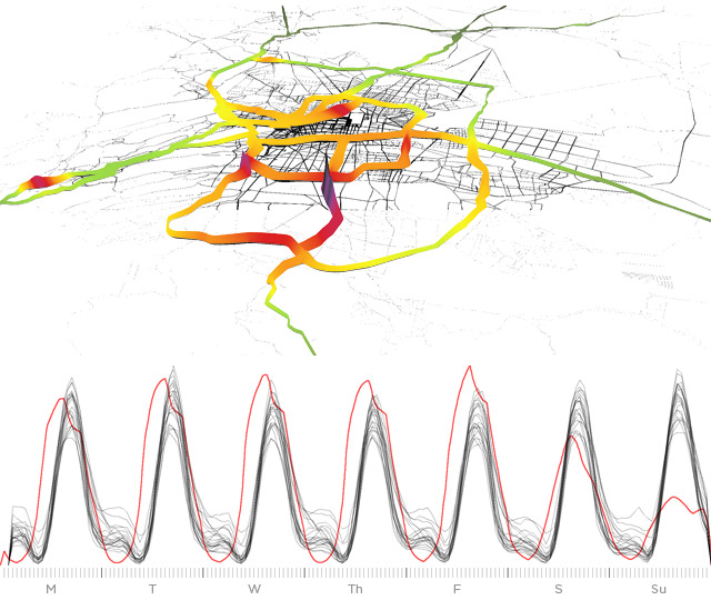
Ozone, produced by the reaction of the UV spectrum in sunlight with vehicle emissions, has a delayed onset, with levels climbing after the morning commute and persisting throughout the day, and only dissipating after sunset. Mexico City is situated in a valley with very little cross-wind, so the ozone is slow to dissipate.
Carbon Monoxide, a product of combustion, is follows closely to the daily commutes, with a large spike in the morning, and a smaller peak in the evening. Like ozone, carbon monoxide tends to settle to low-lying areas, and we see a significant concentration in the center of the city.
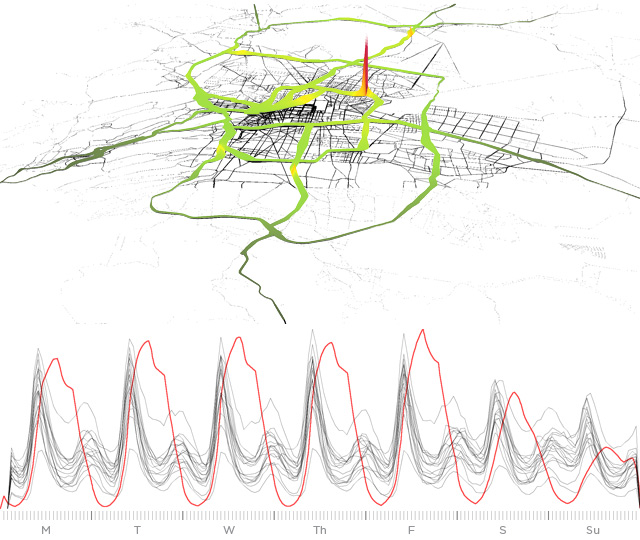
Sulfur Dioxide is another byproduct of combustion, and a major contributor to smog, acid rain, and atmospheric particulates. This pollutant shows a significant improvement, most likely a result of the mandate requiring catalytic converters passed in the 1990s.
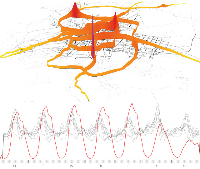
Particulate matter, commonly known as soot, is the byproduct of hydrocarbon combustion, and a major aggravator of pulmonary diseases, such as asthma and COPD. Mexico City's high elevation causes combustion to be less efficient, and thus produces a greater quantity of particulate matter. These small particles contribute to smog, coat exterior surfaces, and like carbon monoxide and ozone, are sheltered from ventilating wind by the sunken valley the city sits in.